Sana (river)
From Wikipedia, the free encyclopedia
(Redirected from Sana River)
Jump to navigation Jump to search
 The Sana river - upper section, between the municipalities of Oštra Luka and Prijedor. |
|
| Sana Location Bosnia and Herzegovina : Country |
|
Physical characteristics |
|
| Source Ribnik, Western Bosnia and Herzegovina : • location |
|
| 44.3173773°N 16.8365586°E : • coordinates | |
| Mouth | |
| Una river, in Bosanski Novi, Bosnia and Herzegovina : • location | |
| 45.051°N 16.383°ECoordinates: 45.051°N 16.383°E : • coordinates | |
| 141.9 km (88.2 mi) [1] : Length | |
| Basin size 4,258 km2 (1,644 sq mi) [1] : Basin features |
|
| Una→ Sava→ Danube→ Black Sea : Progression | |
Sana (Serbian Cyrillic: Сана, pronounced [sǎːna]) is a river in the north-western part of Bosnia and Herzegovina. It is a tributary of the Una, into which it flows near Bosanski Novi. It is the longest of the nine rivers that flow through Sanski Most, and is 142 km long. It is not a navigable waterway.
Contents
Name
The name of the river derives from the Latin word sana, which means "healthy".
Course and sections

The Sana and Ribnik rivers wellspring groups
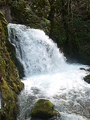
One of three major wellsprings of the Sana
Springs and Upper Sana

The Ribnik river is a short but significant tributary of the Sana
The Sana in its upper course is fast mountain river with upland freshwater ecology, and its waters being very clear and cold. Gushing out of the karst plateau with Ovčara as most prominent summit (1576 m), between Klekovača and Vitorog mountains, and flows toward alluvial plains of the Bosanska Krajina with lowland freshwater ecology. Well-spring areal is located in the vicinity of Marići village, between surrounding villages of Gornja and Donja Pečka, Gornji and Donji Vrbljani, and Medna, on the territories of Ribnik and Mrkonjić Grad municipality not far from the town of Šipovo. The source itself consists of four major and water abundant karstic well-springs, with relatively high average discharge, and after about hundred meters first three individual wellsprings merge with a main course, which is set by the small stream of Korana coming from the right form direction of Gornja Pečka village, receiving the Sana springs one-by-one, with first three supplementing it from the left and, after just a little more than one kilometre downstream, with the fourth from the right. This fourth well-spring is also known for the Mračaj karstic cave from which it emerges. From this point the Sana is formed river, with steady average discharge. The river at this point is still with low average discharge, and receiving the waters of several other smaller streams, but after just about 17 km the Sana meet with its first major tributary, the short but water abundant river, the Ribnik. The area surrounding confluence of the two rivers is called Ribnik, and is divaded between two settlements, Gornji and Donji Ribnik. From Ribnik, the Sana runs through a valley in a south-to-north-northwestern direction as it reach the historic town of Ključ.
Middle course

The Sanica river, lower section, just few kilometres before it meat the Sana.
At this point, passing through Ključ, the upper course ends and river enters its midsection narrow gorge, with steep but relatively low slopes, while turning its course to more clear south-to-north direction. The river here combines with the waters of several typical karstic streams, abundant in water but short in length. Its main tributary is water abundant the Sanica river, which flows east-to-west from the direction of Grmeč mountain, and in this section reaches the Sana from the left at Vrhpolje [bs]. After 72 km and the altitude difference of 262.52 m, the Sana then passes through Sanski Most and combines with the significant tributary rivers, the Dabar, the Zdena and the Bliha river, both from the left, and two other smaller one. From here it runs toward the town of Prijedor, where its middle section ends, and where it receives the waters of Gomjenica river from the right.
Lower Sana

The Sana river in Prijedor
The Sana river at its mouth in Novi Grad
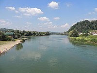
The Sana then turns sharply under an angle of almost 90 degrees and heads west toward its final destination in Bosanski Novi (also known as Novi Grad), where it empties into the Una river as its most important and largest tributary. From Sanski Most, through Prijedor, to its confluence with the Una in Bosanski Novi, average drop is 41.21 m. Between Prijedor and Bosanski Novi, the river also serves as a natural border between the two subregions, Potkozarje and Podgrmeč. In this section the Sana is characteristically lowland river.
Before the war in Bosnia and Herzegovina, a paper mill "Celpak" in Prijedor was draining wastewater into the Sana, just downstream from the town, so that the further flow of the river was considered polluted. From the outset of the war, and after the war to this day, the factory has been shut down and the discharge of wastewater is reduced to significantly smaller scale. At the center of Bosanski/Novi Grad the Sana reaches the Una river.
See also
| Wikimedia Commons has media related to Sana River. |
References
- "Sava River Basin Analysis Report" (PDF, 9.98 MB). International Sava River Basin Commission. September 2009. p. 13. Retrieved 2018-05-18.
- This article incorporates text translated from the Serbian Wikipedia article Сана_(ријека), licensed under cc-by-sa.
'Balkhans' 카테고리의 다른 글
| <펌> Sureanu Mountains (Southern Carpathians) (0) | 2021.01.17 |
|---|---|
| <펌>Croatia (0) | 2021.01.14 |
| <펌> Bosnia and Herzegovina (0) | 2021.01.14 |
| <펌> Romania (0) | 2021.01.13 |
| <펌> Sasu (river) (Romania) (0) | 2021.01.13 |