Desna (river)

From Wikipedia, the free encyclopedia
For other uses, see Desna (disambiguation).
DesnaNative nameLocationCountryCitiesPhysical characteristicsSource • locationMouth • location • coordinatesLengthBasin sizeDischarge • location • averageBasin featuresProgressionTributaries • left • right
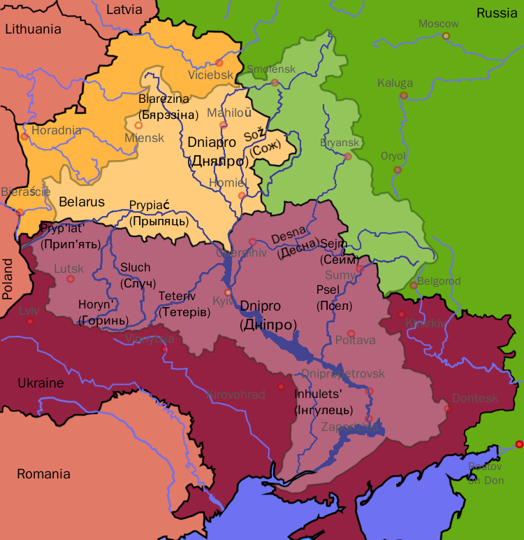 The Dnieper and the Desna rivers' drainage basin. In this map, Belarus is shown in yellow, Russia in green and Ukraine in deep red. |
|
| Russia, Ukraine | |
| Bryansk, Novhorod-Siverskyi, Chernihiv | |
| Smolensk Heights, Russia | |
| Desna Delta | |
| just north of Kyiv, Ukraine | |
| 50°33′02″N 30°32′21″E | |
| 1,130 km (700 mi) | |
| 88,900 km2 (34,300 sq mi) | |
| Kyiv | |
| 360 m3/s (13,000 cu ft/s) | |
| Dnieper→ Dnieper–Bug estuary→ Black Sea | |
| Seym, Oster | |
| Sudost | |

The Desna (Russian: Десна́; Ukrainian: Десна) is a river in Russia and Ukraine, a major left-tributary of the Dnieper. Its name means "right hand" in the Old East Slavic language.[citation needed] It has a length of 1,130 km (702 mi), and its drainage basin covers 88,900 km2 (34,324 sq mi).[1]
In Ukraine, the river's width ranges from 60 to 250 metres (200 to 820 ft), with its average depth being 3 m (10 ft). The mean annual discharge at its mouth is 360 m3/s (13,000 cu ft/s).[1] The river freezes over from early December to early April, and is navigable from Novhorod-Siverskyi to its mouth, a length of about 535 km (332 mi).[1]
The water level of the river reached its lowest recorded point in 140 years in June 2020. This water level was 5 m (16 ft) below normal for that time of year.[2]
Geography[edit]
Course[edit]
The Desna originates in the Smolensk Heights of Smolensk Oblast, Russia. The river's source lies in Yelninsky District, east-southeast from the city of Smolensk and not far from Yelnya in a forest near the village of Naleti. The Desna then flows south through a low and swampy valley toward the city of Bryansk, where the river's right bank rises.
After its confluence with the Seym near the Russian-Ukrainian border, the river then widens, splitting into numerous smaller branches. Its right bank declines again near the city of Chernihiv, and again near one of its tributaries, the Oster, where the Desna continues its course through a low, muddy plain until it finally reaches its mouth near Kyiv at the Dnieper River.
Tributaries[edit]
The Desna has many tributaries. The most significant (length more than 100 km) are, from source to mouth:
Cities and towns on the Desna[edit]
- Yelnya, Russia
- Desnogorsk, Russia
- Zhukovka, Russia
- Seltso, Russia
- Bryansk, Russia
- Trubchevsk, Russia
- Novhorod-Siverskyi, Ukraine
- Chernihiv, Ukraine
- Oster, Ukraine
- Kyiv, Ukraine
- Snov'yanka, Ukraine
The Svensky Monastery is located at the confluence of the Desna and the Sven River.
See also[edit]
References
'흑해 주위 River, cities' 카테고리의 다른 글
| <펌>List of longest rivers of Ukraine (0) | 2024.01.01 |
|---|---|
| <펌> Seym (river) (0) | 2024.01.01 |
| <펌>Rasputitsa (0) | 2024.01.01 |
| <펌>Southern Bug (river) (0) | 2024.01.01 |
| <펌>Sarkel (0) | 2023.12.30 |