Armenian Highlands
| Armenian Highlands | |
|---|---|
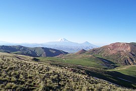
 The Armenian Mountain Range near the Turkey-Iran border | |
| Highest point | |
| Peak | Mount Ararat 39°43′N 44°16′E |
| Elevation | 5,137 m (16,854 ft) |
| Dimensions | |
| Area | 400,000 km2 (150,000 sq mi) |
| Geography | |
| Countries | |
| Region | West Asia |
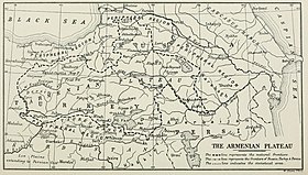
The Armenian Highlands (Armenian: Հայկական լեռնաշխարհ, translit. Haykakan leṙnašxarh; also known as the Armenian Upland, Armenian plateau, Armenian tableland,[1] or simply Armenia) is the central-most and highest of three land-locked plateaus[1] that together form the northern sector of the Middle East. To its west is the Anatolian plateau which rises slowly from the lowland coast of the Aegean Sea and converges with the Armenian Highlands to the east of Cappadocia. To its southeast is the Iranian plateau, where the elevation drops rapidly by about 600 metres (2,000 ft) to 1,500 metres (5,000 ft) above sea level.[1] The Caucasus extends to the northeast of the Armenian Highlands. To the southwest of the Armenian Highlands is Upper Mesopotamia.
During the Iron Age, the region was known by variations of the name Ararat (Urartu, Uruatri, Urashtu). During Antiquity, it was known as "Armenia Major," a central region to the history of Armenians, and one of the four geo-political regions associated with Armenians, the other three being Armenia Minor, Sophene, and Commagene.[2][3]
Since the 1040s the highlands have been under the rule of various Turkic peoples and the Safavid dynasty. Much of Eastern Armenia, which had been ruled by the Safavids from the 16th century, came under Russian control in 1828. While much of Western Armenia was under the rule of the Ottomans and later incorporated into Turkey. The highlands are divided into western and eastern regions, defined by the Ararat Valley where Mount Ararat is located. The region to the west of the Ararat Valley, which was conventionally called "Western Armenia", is now part of present day eastern Anatolia, and the region to the east, which was conventionally called "Eastern Armenia," is now referred to as "Lesser Caucasus" or "Caucasus Minor."
The region was historically mainly inhabited by Armenians, and minorities of Assyrians, Georgians, Greeks, Jews, and Iranians. During the Middle Ages, Arabs and particularly Turkmens and Kurds settled in large numbers in the Armenian Highlands. The Christian population of the western half of the region was exterminated during the Armenian Genocide of 1915 and on a smaller scale the Assyrian Genocide and Greek Genocide.
Today, the eastern half is mainly inhabited by Armenians, Azerbaijanis, and Georgians, while the western half is mainly inhabited by Azerbaijanis, Kurds (including Yazidis), Turks, and Zazas, with a minority of Assyrians.
Contents
Geography
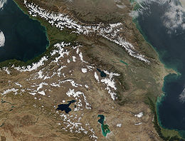
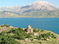
The Armenian Highlands is part of the Alpide belt, forming part of the Asian range that stretches from the Pontic Mountains to the Malay Peninsula. Its total area is about 400,000 km2.[4] Historically, the Armenian Highlands have been the scene of great volcanic activity.[5] Geologically recent volcanism on the area has resulted in large volcanic formations and a series of massifs and tectonic movement has formed the three largest lakes in the Highland, Lake Sevan, Lake Van and Lake Urmia.[6] The Armenian Highlands are rich in water resources.[7]
Most of the Armenian Highlands is in present day eastern Anatolia, and also includes northwestern Iran, all of Armenia, southern Georgia, and western Azerbaijan.[4] Its northeastern parts are also known as Lesser Caucasus, which is a center of Armenian culture.[8]
History
From 4000 to 1000 BC, tools and trinkets of copper, bronze and iron were commonly produced in this region and traded in neighboring lands where those metals were less abundant.[citation needed] It is also traditionally believed to be one of the possible locations of the Garden of Eden.[9]
The Armenian Plateau has been called the "epicenter of the Iron Age", since it appears to be the location of the first appearance of Iron Age metallurgy in the late 2nd millennium BC.[10]
In the Early Iron Age, the Kingdom of Van controlled much of the region, until it was overthrown by the Medes and Orontid dynasty.
In Gilgamesh, the land of Aratta is placed in a geographic space that could be describing the Armenian plateau.[11]
Throughout Classical Antiquity and the Middle Ages, during various centuries, the Armenian Highlands was a heavily contested territory of the Iranian Parthian Empire, Sassanid Persian Empire, Byzantine Empire, and the Arab Caliphate.[12]From the early modern era and on, the region came directly under Safavid Iranian rule. Heavily contested for centuries between the Iranian Safavids and its vying archrival the Ottoman Empire with numerous wars raging over the region, large parts of the Highlands comprising Western Armenia were finally conquered by the Ottoman Empire in the first half of the 17th century following the Ottoman–Safavid War (1623–39) and the outcoming Treaty of Zuhab,[13] while Eastern Armenia, forming another major part of the Highlands, stayed in Iranian hands up to the course of the 19th century, when it was ceded to Imperial Russia. During the later first half of the 19th century, the Ottoman held parts of the Armenian Highlands comprising Western Armenia now formed the boundary of the Ottoman sphere of influence and the Russian sphere of influence, the latter who had just recently completed its conquest of the Caucasus and Eastern Armenia at the expense of its suzerain, Qajar Iran, in about 4 major wars spanning more than two centuries.[14]
According to Richard Hovannisian, the Armenian Genocide was the "physical elimination of the Armenian people and most of the evidence of their ever having lived on the great highland called the Armenian Plateau, to which the perpetrator side soon assigned the new name of Eastern Anatolia".[15] Since the Armenian Genocide and dissolution of the Ottoman Empire after World War I, it has been the boundary region of Turkey, Iran and the Soviet Union and, since the 1991 dissolution of the Soviet Union, Armenia, and parts of Georgia and Azerbaijan.[11]
Middle Ages: Turkish and Persian conquests
Seljuk Turks first arrived in the Armenian highlands in the 1040s and expanded westward conquering territories and populating the peninsula until finally the Ottoman Empire was declared in 1299.[16] The Seljuks victory at the Battle of Manzikert ushered in the most catastrophic four and a half centuries in Armenia's history. Most of the Armenian population suffered an unrelenting devastation, but Ruben I, Prince of Armenia led some of the Armenians out of the highlands and escaped into the mountains of Cilicia where they founded a new principality that was not in the Turkish line of fire.[17]
Armenia's troubles began with the Seljuks but there was more to come. In the early 13th century, as various peoples fled from the advancing Mongol onslaught, the highlands were once again disturbed by the migrations of the Karluk and Kharizmian peoples. The Mongols, who did not distinguish between Christianity and Islam, reached the highlands in 1235. With their arrival, Armenia became part of "the East" in its entirety for the first time since the territory was partitioned during the Byzantine–Sasanian wars. Considered the successors of the Abbasids, Sassanidss and Seljuks, the Mongols eventually converted to Islam and established their dynasty in Azerbaijan.[17]
In 1410 the area was ruled by Kara Koyunlu who ruled until 1468. The pastoral culture of the Kara Koyunlu Turks undermined agricultural practices in Armenia. In 1468, the Ak Koyunlu Turks assumed power; their reign lasted until 1502 when the Safavids place Armenia under Iranian rule. The Ottoman Turks don't take control of the highland region until 1514, several decades after Armenians in the Ottoman Empire are given milletstatus. The highlands come under Ottoman control following the defeat of the Safavids at the Battle of Chalderon; they appointed Kurdish tribesman to rule over the highlands' local administrative affairs. By 1516, the Ottoman Empire has conquered all of the formerly Armenian lands, including Cilicia.[18]
Flora and fauna
The apricot was known by the Romans as the prunus armenicus (the Armenian plum) and was brought to Europe from the Armenian plateau.[1]
Notable peaks
| Rank | Mountain | Prominence | Location |
|---|---|---|---|
| 1 | Mount Ararat | 5,137 m | |
| 2 | Mount Aragats | 4,095 m | |
| 3 | Mount Süphan | 4,058 m | |
| 4 | Mount Kapudzhukh | 3,906 m | |
| 5 | Mount Azhdahak | 3,597 m | |
| 6 | Mount Kezelboghaz | 3,594 m | |
| 7 | Mount Artos | 3,515 m |
See also
'코카서스' 카테고리의 다른 글
| <펌> Azerbaijan (0) | 2019.02.15 |
|---|---|
| <펌> Georgia (Country) (0) | 2019.02.15 |
| <펌>Tbilisi (0) | 2019.02.15 |
| <펌> Narikala (0) | 2019.02.15 |
| <펌>Greater Armenia, Ancient Kingdom, Armenia (0) | 2019.02.10 |


