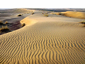
Karakum Desert
| Karakum Desert | |
|---|---|
 Sand dunes in the Karakum Desert of Turkmenistan | |
 The Karakum Desert by NASA World Wind | |
| Area | 350,000 km2 (140,000 sq mi) |
| Geography | |
| Coordinates | 40.5°N 60°E |
The Karakum Desert, also spelled Kara-Kum and Gara-Gum (Turkmen: Garagum, pronounced [ɡɑɾɑˈɡʊm]; Russian: Караку́мы, tr. Karakumy, IPA: [kərɐˈkumɨ];), is a desert in Central Asia. Its name means Black Sand in Turkic languages, in reference to the dark soil that lies beneath the sandy surface of much of the desert.[1] It occupies about 70 percent, or 350,000 km², of the area of Turkmenistan.
The population is sparse, with an average of one person per 6.5 km² (one person per 2.5 square miles). Rainfall is also sparse, ranging from 70 to 150 mm per year.[2]
Contents
Location
Covering much of present-day Turkmenistan, the Karakum Desert lies east of the Caspian Sea, with the Aral Sea to the north and the Amu Darya river and the Kyzyl Kum desert to the northeast. In modern times, with the shrinking of the Aral Sea, the extended "Aral Karakum" has appeared on the former seabed, with an estimated area of 15,440 sq mi/40,000 km². Although the level of the Aral Sea has fluctuated over its existence, the most recent level drop was caused by the former Soviet Unionbuilding massive irrigation projects in the region.[citation needed] Although the North Aral Sea is currently rising, the South Aral Sea is still dropping, thus expanding the size of the desert.[3]
The sands of the Aral Karakum are made up of a salt-marsh consisting of finely-dispersed evaporites and remnants of alkaline mineral deposits, washed into the basin from irrigated fields. The dust blown on a full east-west airstream carry pesticide residues that have been found in the blood of penguins in Antarctica[citation needed]. Aral dust has also been found in the glaciers of Greenland, the forests of Norway and the fields of Russia[citation needed].
Geology
The Karakum Desert is home to the Darvaza Gas Crater.
The area has significant oil and natural gas deposits.[citation needed]
Hydrography
To the south the Murghab and Tejen rivers flow out of the Hindu Kush Mountains, flow west, and empty into the desert, providing water for irrigation.
The desert is crossed by the second largest irrigation canal in the world, the Karakum Canal, which brings water from the Amu Darya to southern regions of the desert.[1]Construction on the canal was started in 1954 and completed in 1958.[1] It is 1,375 km in length, and carries 13-20 km³ of water annually.[1] Leakages from the canal have created lakes and ponds along the canal and the rise in groundwater has caused widespread soil salination.[citation needed]
Archaeology
Within the Karakum are the Uly (Big) Balkan, a mountain range in which archaeologists have found human remains dating back to the Stone Age.
Economy and resources
The oases of Mary and Tejen are noted for cotton growing.
Features
The Darvaza gas crater, also called the "Door to Hell" or the "Gates of Hell" by locals, a crater of natural gas that has been burning since 1971, is located in the Karakum Desert. The crater is a major tourist attraction, with hundreds of visitors arriving each year.[4]
Transport
The desert is crossed by the Trans-Caspian Railway.
'중앙아시아' 카테고리의 다른 글
| <펌> 실크로드 (0) | 2019.02.03 |
|---|---|
| <펌> 비단길 (0) | 2019.02.03 |
| <펌>Kyzylkum Desert (0) | 2019.02.02 |
| <펌> Uzbekistan (0) | 2019.02.02 |
| <펌> Uzbekistan on the Silk Road (0) | 2019.02.02 |


