2023/05/17(7)
-
<펌>Oxus river
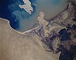
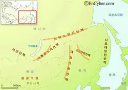
Oxus River Jump to navigationJump to search Author:Laxman Burdak, IFS (Retd.) Map showing the location of the Aral Sea and the watersheds of the Amu Darya (orange) and Syr Darya (yellow) which flow into the lake. National capitals in bold. Marghab-Hari-Rud-Kabul-Amu-Darya-River-Basins Location of Amu Darya on map of Baktria Amu Darya (Oxus River) Delta from space, November 1994. Map of area arou..
2023.05.17 -
<펌>Amu Darya
Amu Darya From Wikipedia, the free encyclopedia This article is about the river. For the town, see Amu Dar'ya (town). "Oxus" redirects here. For other uses, see Oxus (disambiguation). Amu DaryaOxus, Wehrōd, də Āmu Sind, Amu RiverEtymologyNative nameLocationCountriesRegionPhysical characteristicsSource • location • coordinates • elevation2nd source • location • coordinates • elevationSource confl..
2023.05.17 -
<펌>Stanovoy Range
Stanovoy Range From Wikipedia, the free encyclopedia This article is about the mountain range in Yakutia. It is not to be confused with the Stanovoy Highlands in the Transbaikal area. Stanovoy RangeHighest pointPeakElevationCoordinatesDimensionsLengthWidthGeographyCountryFederal subjectRange coordinatesParent rangeGeologyType of rock Outer Khingan View of some larch woods in the range. Skalisty ..
2023.05.17 -
<펌>Argun (Amur) river
Argun (Amur) 59 languages From Wikipedia, the free encyclopedia For other uses, see Argun (disambiguation). ArgunEtymologyNative nameLocationCountryRussian KraiChinese RegionPhysical characteristicsSource • location • coordinates2nd source • location • coordinates • elevationMouth • coordinatesLengthBasin sizeDischarge • averageBasin featuresProgression Taken from Shiwei, Inner Mongolia, China. ..
2023.05.17 -
<펌> Udy river
Udy (river) From Wikipedia, the free encyclopedia UdyNative nameLocationCountryPhysical characteristicsMouth • coordinatesLengthBasin sizeBasin featuresProgression The river in spring Уды (Russian) Уди (Ukrainian) Russia, Ukraine Donets 49.7983°N 36.6119°ECoordinates: 49.7983°N 36.6119°E 164 km (102 mi) 3,890 km2 (1,500 sq mi) Donets→ Don→ Sea of Azov The Udy (also: Uda, Russian: Уды, Ukrainian:..
2023.05.17 -
<펌.스타노보이 산맥 - 세계지명유래사전
세계지명 유래사전 스타노보이 산맥 [ Stanovoi Mts. ] 러시아 연방 극동 지방에 있는 산맥. 동서 방향으로 뻗어 있으며 '중앙 척추'라는 뜻이다. 최고봉은 2,412m나 되지만 대체로 1,500m 이하의 저산성 산맥이다. 아무르 강과 레나 강이 남쪽과 북쪽에 있으며 태평양과 북극해의 분수령이 된다. 레나 강의 발원지이며 야쿠츠크까지 철도로 갈 수 있다. 철광석, 금, 은, 구리 등의 지하 자원이 매장되어 있다. [네이버 지식백과] 스타노보이 산맥 [Stanovoi Mts.] (세계지명 유래 사전, 2006. 2. 1., 송호열)
2023.05.17