앞의 두글에서 필자는 위례성과 한산, 한산성, 한성 등에 대해서 백제와 관련 자료를 바탕으로 살펴 보았는데, 그 중에서 위례성은 한성과는 다른 위치임을 알았다. 그래서 먼저 위례성에 대한 서양사 자료를 검토하고자 한다.
위례성은 백제의 건국지로서 그 의미가 있다. 현재로서는 한산이 위례성 가까이 있는지 보류하며, 위례성의 위치 추정을 검토하고자 한다. 위례성이 우선 발칸반도 일리리아 지역으로 추정하는 이유는 다음과 같다.
1) 백제의 건국지 설에 패대지간설, 대방고토설과 진번지간설이 있다.
지난 글에서도 언급되었지만, 패대지간설은 패수와 대수를 건너 가서 건국했다는 것이다. 필자는 패수는 북으로 흐르는 라인강, 동남으로 흐르는 다뉴브강으로 추정했다. 대수는 현재로서는 대방군지역에 있는 강이 아닌가 한다. 다뉴브강이 될 수도 있다. 따라서 패수와 대수를 건너간 지역은 판노니아, 발칸반도 달마티아지역이 아닐까 한다.
대방고토설은 옛 대방땅에 구태가 건국했다는 것이다. 필자는 대방군 지역은 발칸반도내에 있는 것으로 추정하고 있다. 구태는 Augustus로 추정한다. 따라서 대방고토를 Dalmatia지역으로 추정한다.
진번지간설은 진한과 진번 사이에 있다는 설이다. 진한은 발칸반도 남쪽 소아시아지역에서 동쪽으로 추정하고 있다. 진번 임둔은 발칸반도 서북쪽으로 추정한다. 그동안 낙랑에 대한 연구 결과 얻은 결론이다. 따라서 진번지간설의 위치는 발칸반도이다. 따라서 위례성의 위치가 발칸반도의 서쪽 Illyria지역이 아닌가 한다.
2) Augustus와 온조 비교시 위례성 또는 한산의 위치 백제사에서의 온조는 서양사에서 Augutus로 나타나는 것이 아닌가 한다.
위태, 구태가 백제를 세웠다고 중국 사서는 말한다 하는데, 위태, 구태 등은 Augutus를 언급하는 것으로 추정된다.
"중국 사서에 등장하는 구태와의 관계
한편 외국 기록인 위서 백제전, 북사 백제전, 주서, 수서, 책부원귀 등에서는 구태가 백제의 시조라고 전해지고 있는데 위의 우태와 음이 통하는 듯 해서 동일인물로 보기도 한다. "
(자료 : 온조, 나무위키, 필자의 다음 블로그, 카테고리, 백제, 펌글 참조)
3) Dalmatia지역은 위례성인가?
실제 고주몽으로 추정되는 Caesar가 암살되었을 당시, Augutus는 Dalmatia지역에 있었다고 한다. 즉 위례성이 Illyria지역인 Dalamtia지역이 될 수 있는 것이다. 그리고 로마 역사에서 이 지역 출신 황제들이 여럿이 나왔다. 따라서 위례성이 있는 지역으로 주목된다.
4) 마한은 이태리반도를 포함한다.
위만은 패수를 건너 진나라의 고공지역인 상하장에 도읍 (왕검성)했다 한다. 즉 고조선의 도읍지인 왕검성이 진나라에 의해 정복되었다는 것을 의미한다. 필자는 한(漢)나라와 조선의 경계가 되는 패수가 라인강이 아닌가 추정했다. (본 블로그 글, '한나라와 조선의 경계는 독일의 라인강이 아닌가?' 참조). 단군조선의 '준왕'은 위만에 망한 후, 남쪽으로 내려가 마한왕을 격파하고 삼한의 왕이 되었다 했다.
위만의 왕검성이 이태리 북부 론강지역이라면, 남쪽으로 내려간 지역은 이태리 반도가 된다. 즉 마한의 중심지는 이태리 반도가 되는 것이다. 월지국(목지국)이 마한의 중심국이라 했는데, 이태리반도에 있을 수 있는 것이다. 월지국은 월지족이 아닌가 한다. 월지족은 흉노에 의해 자꾸 서쪽으로 이동했다고 역사는 말하고 있다. 유럽으로 이동한 동양문화의 민족은 부여족(Bulgars)과 훈족(Huns)이라 서구 역사가들은 말하고 있다. 즉 월지족이 부여족이 아닌가 한다. 그래서 월지국은 부여국이 아닌가 추정한다. 필자는 광개토태왕이 정벌한 동부여를 이태리북부지역으로 추정했는데, 이러한 추정에도 연관이 있다. 즉 마한의 중심지역으로 이태리반도를 추정하고 있고, 마한의 동북쪽에 건국한 백제는 그래서 발칸반도에 있다는 추정이다.
5) 최근에 알게 된 삼국유사의 내용에 위례성은 곧 사천(蛇川)이라 했다는 기록이다. 그런데 발칸반도 루마니아에 Sasu River란 조그만 지천이 있다. Sasu는 우리말 사수이다. 물수자로 추정된다. 따라서 사천이 Sasu river 아니면 그 근처의 강일 수 있다.
이상의 조건을 고려할 때, 위례성은 발칸반도의 서쪽 Dalmatia지역의 Sirmium, 즉 Illyrian이 사는 지역인 Illyricum지역이 아닐까 한다. 서쪽이 아드리아해 바다로 막혀 있고 동쪽은 높은 산 (디나르 알프스산맥)이 있으며, 남쪽으로는 기름진 땅이다.
이곳은 이태리반도의 마한에서 보면 동북쪽이며, 마한의 북쪽 낙랑에 가까우며, 진한의 북쪽이며, 흑해, 에게해에 접한 동예와 가깝다. 따라서 온조가 위례성에 백제를 건국했을 때, 주위의 토착세력인 낙랑과 동예가 공격해 오고 이들과 마찰을 빚는 것은 당연하다 할 것이다.

BC 2C의 일리리아 왕국 지도 (자료 : 위키피디아)
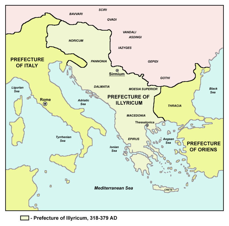
기원후 4세기의 로마 Illyricum 지역 지도 (자료 : 위키피디아)
이상의 추정은 이 지역이 로마의 역사지역이므로, 로마사에서 이와 관련된 역사적 사건들을 발견하면 이러한 추정에 대한 방증이 될 수 있을 것이다. 아래에서는 이에 대한 자료를 검토해 보고자 한다. 먼저 지리적 검토를 하고 이후 역사적 사건을 검토하고자 한다.
우선 위례성은 하남 위례성이라 했다. 따라서 어느 강 아래 있다는 것이다. 그래서 강에 대해 먼저 살펴보자.
먼저 삼국사기에 언급된 위례성, 사천과 관련될 지도 모르는 Sasu river에 대해 알아 보자
1) Sasu river - Strei - Mures River
Sasu River는 루마니아 북쪽 Sureanu Mountains에 있는 강인데 Strei river의 좌측 지류로서 10km의 조그만 지천이라 한다. (아래 자료 참조). 다소 실망스럽지만, 우리말 물수자가 있는 강이니 우리 조상들의 역사가 있는 곳으로 추정된다. 필자는 본 블로그 글, '광개토태왕 비문을 통한 정벌지역 추정'에서 사수성이 이 Sasu river근처에 있는 유럽에서 제일 큰 성중의 하나로 루마니아의 7대 불가사의 중 하나인 Corvin Castle (Hunedoara Castle)이라 추정했다.
(1) Sasu River
"The Sasu is a river in the Șureanu Mountains, north of Petroșani, Romania. It is a left tributary of the Strei.[1][2] Its length is 10 km (6.2 mi) and its basin size is 17 km2 (6.6 sq mi).[2] "
(source : Sasu, wikipedia, 필자의 다음 블로그, 카테고리, Balkhans, 펌글 참조)
Sasu river의 모천인 Strei river는 93km길이로 다시 Mures River의 지류이다.
(2) Strei River
"The Strei (Hungarian: Sztrigy) is a left tributary of the river Mureș in Transylvania, Romania.[1][2] The upper reach of the river, upstream of the village of Baru, is also known as Râul Petros. It flows through the town Călan and the villages Petros, Baru, Livadia, Pui, Galați, Băiești, Ohaba de sub Piatră, Ciopeia, Subcetate, Covragiu, Bretea Română, Bretea Streiului, Ruși, Strei, Streisângeorgiu, Batiz, Băcia and Simeria Veche. It discharges into the Mureș near Simeria. Its length is 93 km (58 mi) and its basin size is 1,983 km2 (766 sq mi).[2]
Tributaries
The following rivers are tributaries to the river Strei (from source to mouth):[2]
- Left: Sasu, Jigureasa, Jiguroșița, Crivadia, Bărușor, Valea Verde, Bărbat, Rușor, Râul Alb, Paroș, Sălaș, Râul Mare, Silvaș, Valea Râpelor, Nădăștia, Sâncrai
- Right: Ohaba, Văratec, Valea Mare, Valea Tiliilor, Gânțaga, Valea Voinii, Valea Luncanilor, Săcel, Valea Făgetului "
(source : Srei, wikipedia, 필자의 다음 블로그, 카테고리, Balkhans, 펌글 참조)
Sasu river의 모천 Sitrei river의 모천인 Mures river에 대해 알아 보자
(3) Mures River
789km (490 마일)의 큰 강인 Mures River는 라틴말로는 Marisus라 한다. 즉 마리수이다. 물수자가 들어 간다. 역시 우리 조상들의 흔적이다. 우측에 Carpathian mountains이 있다. (아래 지도 참조). 헤로도투스나 스트라보에 의해 언급되는 강이니 만큼 역사에서 상당히 중요한 강이었음에 틀림없다. 색슨족이 트란실바니아에 거주하는 곳이며, 합스부르그 지배때문에 독일에도 알려진 강이다.
"The Mureș (Romanian: [ˈmureʃ]; Hungarian: Maros, IPA: [ˈmɒroʃ]; Serbian: Мориш, romanized: Moriš) is a 789-kilometre-long (490 mi) river in Eastern Europe. Its drainage basin covers an area of 30,332 km2 (11,711 sq mi).[1]:22 It originates in the Hășmașu Mare Range in the Eastern Carpathian Mountains, Romania, rising close to the headwaters of the river Olt, and joins the Tisza at Szeged in southeastern Hungary. In Romania, its length is 761 km (473 mi) and its basin size is 27,890 km2 (10,770 sq mi).[2]
The Mureș River flows through the Romanian counties Harghita, Mureș, Alba, Hunedoara, Arad and Timiș, and the Hungarian county Csongrád.
The largest cities on the Mureș/Maros are Târgu Mureș, Alba Iulia, Deva and Arad in Romania, and Makó in Hungary.
The Hungarian reaches of the Mureș/Maros are 73 km (45 mi) long as the state border. Some 28.5 km2 (11.0 sq mi) on the northern side of the river are protected as part of the Körös-Maros National Park. The Maros Floodplain Protected Area consists of gallery forests, floodplain meadows and 0.6 km2 (0.23 sq mi) of forest reserve near Szeged.
Salt used to be traded in medieval times on the river on large rafts.
The river is known to be first mentioned by Herodotus in 484 BC bearing the name Maris (Μάρις).[3] Strabo calls it Marisos (Μάρισος).[4] It was known in Latin as the Marisus; It is also mentioned in 948 AD, in a document of the Byzantine Emperor Constantine VII, under the name Moreses (Μορήσης).[5][6]
It was also known in German variously as the Mieresch, Marosch or Muresch, owing to Transylvanian Saxon settlements and prior Habsburg rule. It was known in Turkish as the Maroş or Muriş under the Ottomans.
(source : Mures, Wikipedia, 필자의 다음 블로그, 카테고리, Balkhans, 펌글 참조)


Map of Mures River (source : Wikipedia)
(By Meichs - selbst erstellt nach Romania ape relief.png aus ro-wikipedia (user:Pixi), CC BY-SA 3.0, https://commons.wikimedia.org/w/index.php?curid=4159447)
Sasu river에 관한 분석은 그 모천인 Strei river, Mures River로 이어졌다. 그러나 이들은 루마니아 중앙을 가로지르는 강으로서 바닷가 위치와는 거리가 있다. 그리고 다뉴브강의 북쪽에 위치하며, 아래가 산악지형으로 되어 있어 남으로 기름진 땅이라는 건국지의 지형과 다른 양상을 보인다. 단 Sasu river근처의 Corvin Castle (Hunedoara Castle)이 유럽의 제일 큰 성중의 하나로서, 루마니아의 7대 불가사의 중 하나라고 하니 이를 잠시 살펴보자.

Corvi Castle (Hunadoara Castle)
Hunadoara Castle 훈족의 성이라는 이름으로 보이는 Corvin Castle은 Tower가 있는 것으로 보아 광개토태왕시 세운 고구려의 성일 가능성이 높다. 즉 사수(沙水)성이라는 것이다. 위례성의 가능성은 여러 지형상 조건과 더불어 가능성이 희박해보인다.
따라서 사수와 이름이 비슷하면서 다뉴브강의 아래 있는 Sava River에 대해 알아 보자. Sava river의 지류인 Una river의 지류, Sana River가 있는데, 광개토태왕시 정벌한 성 중에 산나성이 있다.
2) Sava river

Map of Sava river in Illyria and Dalmatia (source : Wikipedia)
(1) Sava River
Sava River는 다뉴브강의 우측 지류이다. 세르비아 수도 벨그라드로 흐른다. 판노니아 평원의 남쪽 경계로서 발칸반도의 북쪽 경계가 된다. 길이는 990km, 615마일이다. 다뉴브강의 지류중 제일 수량이 많은 강이다. 이 강이름은 인도유럽어로부터 온 것으로 고대 그리스인들은 Saos라 불렀다. Saos, 사오스, 사수와 유사하다. 위례성이 이 근처 지역인지 모른다. 그래서 유심히 관찰할 필요가 있다.
"The Sava (/ˈsɑːvə/;[2] Slovene pronunciation: [ˈsàːʋa],[3] Serbo-Croatian pronunciation: [sǎːʋa];[4] Serbian Cyrillic: Сава, Hungarian: Száva) is a river in Central and Southeast Europe, a right tributary of the Danube. It flows through Slovenia, Croatia and along its border with Bosnia and Herzegovina, and finally through Serbia, feeding into the Danube in its capital, Belgrade.
The Sava forms the main northern limit of the Balkan Peninsula, and the southern edge of the Pannonian Plain. The Sava is 990 kilometres (615 miles) long, including the 45-kilometre (28 mi) Sava Dolinka headwater rising in Zelenci, Slovenia. It is the greatest tributary of the Danube by volume of water, and second-largest after the Tisza in terms of catchment area (97,713 square kilometres (37,727 square miles)) and length. It drains a significant portion of the Dinaric Alps region, through the major tributaries of Drina, Bosna, Kupa, Una, Vrbas, Lonja, Kolubara, Bosut and Krka. The Sava is one of the longest rivers in Europe and among the longest tributaries of another river. The population in the Sava River basin is estimated at 8,176,000, and is shared by three capital cities: Ljubljana, Zagreb and Belgrade. The Sava is about 2⁄3-navigable for larger vessels: from the confluence of the Kupa in Sisak a few kilometers below Zagreb.
The name is believed to be derived from the Proto-Indo-European root *sewh1 ('to take liquid', whence the English word sup) and the ending *eh2, so that it literally means 'that which waters [the ground]'.[5] The ancient Greeks called it Saos (Ancient Greek: Σάος).[6][7] "
(source : Sava, Wikipedia, 필자의 다음 블로그, 카테고리, Iliyrians, 펌글 참조)
(2) Una River
Una River는 Sava river의 오른쪽 지류(212km)로 폭포가 아름다운 강으로 알려져 있다. 보스니아 헤르체토비나와 크로아티아의 경계를 이루는 강이다.
"The Una (Serbian Cyrillic: Уна, pronounced [ûna]) is a border river between Bosnia and Herzegovina and Croatia and a right tributary of the Sava river.[1] It is part of the Black Sea drainage basin, and its watershed has a size of 10.200 km², of which 8.080 km² belongs to Bosnia and Herzegovina, and 2.120 km² to Croatia. The total length of the river is 212 km.[2] The source of the river is located in the town of Donja Suvaja in Croatia, and its mouth is located near the town of Jasenovac, on the border with Bosnia. The largest right tributaries are the Krka, Unac, Krušnica and Sana rivers, and the largest left tributary is the Klokot river. Its longest headwater is the Unac river. The largest and most important city located on the river is Bihać. Other, smaller cities and towns are Bosanska Krupa, Novi Grad and Kostajnica. The river is characterized by a multitude of waterfalls, rapids, karst springs and relatively untouched nature. A large part of the upper river is part of the Una National Park."
(source : Una(Sava), Wikipedia, 필자의 다음 블로그, 카테고리, Balkhans, 펌글 참조)
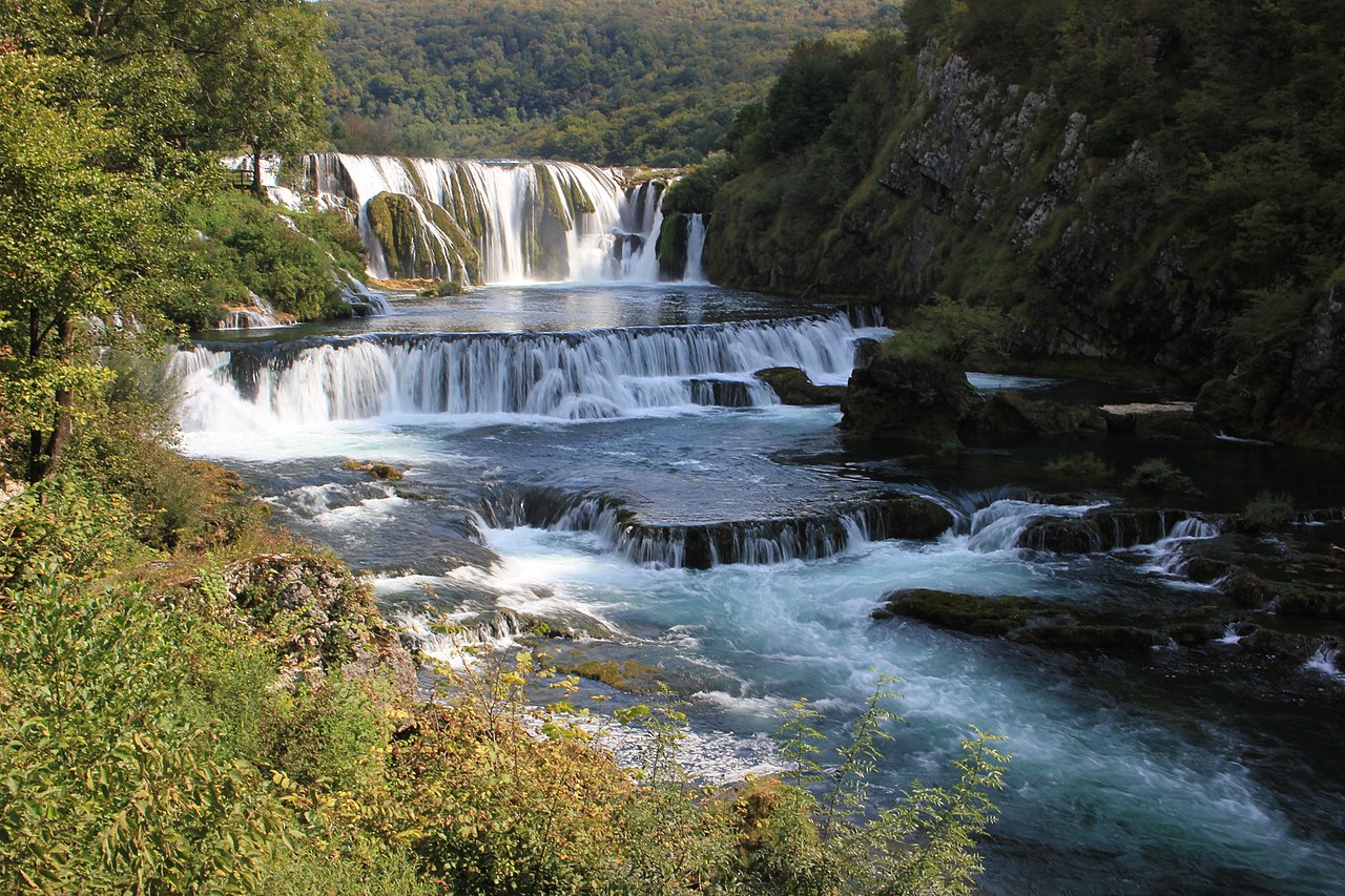
Una River에 있는 Strbacki 폭포 (source : Wikipedia)
(3) Sana River
Una River의 지류인 Sana River (142km)에 광개토태왕이 정벌한 지역으로 추정되는 Mogorjelo 유적이 있다. (본 블로그 글, '광개토태왕 비문을 통한 정벌 지역 추정' 참조) 이것이 산나성이 아닌가 했다. 그러나 아래 사진은 보다 고대의 유적으로 보인다.
"Sana (Serbian Cyrillic: Сана, pronounced [sǎːna]) is a river in the north-western part of Bosnia and Herzegovina. It is a tributary of the Una, into which it flows near Bosanski Novi. It is the longest of the nine rivers that flow through Sanski Most, and is 142 km long. It is not a navigable waterway."
(source : Sana, Wikipedia, 필자의 다음블로그, 카테고리, Balkhans, 펌글 참조)
현재의 유적으로 보아 1세기 중간부터 있던 주거지역이라 하는데 유적이 고조선 유적과 유사하다. 3세기에 화재로 타버렸다 한다. 혹시 백제의 유적인지도 모른다. 388년 Honorius황제 때의 동전이 발견되었다 한다. 그래서 401-403년사이 서고트족에 의해 침범된 지역으로 보인다 한다. 광개토태왕 때 정벌된 성으로 판단된다.

Sana river주위에 있는 1세기부터의 주거지역으로 추정되는 보스니아의 Mogorjelo 유적 (자료 : 위키피디아)
"An Italic settler had a private manor complex built for agricultural purposes on the Mogorjelo site in the mid first century CE.[1] He located the building designed for processing agricultural produce (villa rustica fructuaria) on a salient on the hill (the ground plan of the villa lies near the north or main gate of the walls of later date), and the residential building (villa rustica habitatoria) on the south slope exposed to the sun.[1] This building burned down in the third century.[1] In the early fourth century, a state-owned estate was constructed over the ruins, with a villa which now forms the major feature of the complex.[1] During the third century the property probably changed hands to become state-owned. The villa at Mogorjelo supplied the town of Narone, the ruins of which lie in the village of Vid near Metković.[1] The estate was destroyed in a major fire.[1]
The latest coins discovered on this site, in a layer of soot, were minted by Honorius in 388, so that it may be assumed that Mogorjelo fell into enemy hands some time between 401 and 403 with the Visigoth invasion of these parts.[1] "
(source : Mogorjelo, Wikipedia, 필자의 다음블로그, 카테고리, Balkhans, 펌글 참조)
참고로 이와 유사한 유적의 흔적이 아일랜드 섬에도 있다. Aran islands에 있는 O'Brian castle이다. 고구려식 타워가 있는 것으로 보아 고조선의 그것으로 보인다. 주거시설 유적이 BC 1100년경으로 올라간다 하니 상나라가 망한 후 주나라로 이전할 때 피신한 사람들인지도 모른다. 그러면 광개토태왕시 찾아간 것인지 모른다. 섬 주위는 높은 절벽으로 이루어져 있다. 만약 이 지역이 백제의 관미성 지역일 수도 있지만, 이에 대한 역사적 자료는 현재 없다. 위의 Mogorjelo 유적은 광개토태왕 시기, 서고트족의 침입을 받은 것으로 기술된다.

Inisheer landscape in Aran Island in Ireland(source : Wikipedia)
Sava River 바로 위에 다뉴브강과 연결되는 강이 하나 더 있다. 즉 Drava River이다. 이 강도 판노니아 지역에 있는 주요 강이므로 조사해 보고자 한다.
3) Drava river
Drava river가 대방군의 대(帶)자가 들어 가는 띠와 같은 대수(帶水)가 아닌가 한다. 아래 지도를 보면 다뉴브강 즉 패수아래 대수라 할 수 있는 드라바강이 흐른다. 그 아래에는 Sava river가 흐른다.

Drava River map (source : Wikipedia)
Map of Drava, Sava, Danube Rivers
드라바 강은 길이가 710 km (440 mi)로서 다뉴브강의 지류중 5-6번째로 긴 강이다. 이 강은 동쪽으로 흘러 다뉴브강에 합쳐지며, 크로아티아와 항가리의 국경을 이룬다. 이름은 로마이전, 켈트족 이전의 이름으로, 인도유럽어 어원 dreu (flow뜻) (cf . 산스크리스트어 dravati, 'flow')로부터 온 것으로 본다. (아래 자료 참조). 필자는 대방의 음차가 아닌가 하는 생각도 한다. (Drava -> Dava -> Daeva -> 대방). 그래서 혹시 대수가 아닌가 한다. 패수는 다뉴브강, 대수는 드라바강이 되면 이 근처에 백제의 건국지가 되는 것이 더욱 확실해진다. 드라바강은 이태리에 수원이 있는 다뉴브강의 지류 둘 중의 하나이다.
"The Drava or Drave[2] (German: Drau [ˈdʁaʊ]; Slovene: Drava [ˈdɾàːʋa]; Croatian: Drava [drǎːʋa]; Hungarian: Dráva [ˈdraːvɒ]) is a river in southern Central Europe. With a length of 710 kilometres (440 mi),[1] 724 kilometres (450 mi) including the Sextner Bach source, it is the fifth or sixth longest tributary of the Danube, after the Tisza, Sava, Prut, Mureș and perhaps Siret. Its source is near the market town of Innichen (San Candido), in the Puster Valley of South Tyrol, Italy. The river flows eastwards through East Tirol and Carinthia in Austria into the Styria region of Slovenia. It then turns southeast, passing through Croatia and, after merging with its main tributary Mur, forms most of the border between Croatia and Hungary, before it joins the Danube near Osijek.
Name
In ancient times the river was known as Dravus or Draus in Latin, and Δράβος in Greek. Medieval attestations of the name include Dravis (c. AD 670), Drauva (in 799), Drauus (in 811), Trauum (in 1091), and Trah (in 1136). The name is pre-Roman and pre-Celtic, but probably of Indo-European origin, from the root *dreu̯- 'flow' (cf. Sanskrit: द्रवति dravati 'flow').[3] The river gives its name to the dravite species of tourmaline.[4]
Geography
The Drava (along with one of its tributaries, the Slizza) and the Spöl are the only two rivers originating in Italy that belong to the Danube drainage basin. Its main left tributaries (from the north) are the Isel [de] (contributes 39 m³/s), the Möll (25 m³/s), the Lieser [de] (22 m³/s), the Gurk (30 m³/s) and the Lavant (12 m³/s) in Austria, and the Mur (166 m³/s) near Legrad at the Croatian–Hungarian border. Its main right tributaries (from the south) are the Gail (45 m³/s) in Austria, the Meža (12 m³/s) and Dravinja (11 m³/s) in Slovenia, and the Bednja (? m³/s) in Croatia.
(source : Drava, Wikipedia, 필자의 다음 블로그, 카테고리, Illyrians, 펌글 참조)
위례성과 관련될 수 있는 강의 흐름을 살펴보았는데, Sava River와 Drava river가 주요 관심사가 되었다. Sava river는 고대 그리스인들이 불렀다는 Saos가 사수 즉 삼국유사에서 위례성과 함께 언급된 사천(蛇川)과 관계가 있는 것이 아닌가 하고, Drava river는 대방지역의 대수가 아닌가 한다. 그런데 Drava 강 아래의 Sava강가에는 아래에서 살펴보는 판노니아 지역의 수도 Sirmium이라는 왕궁터가 존재하는 도시가 존재한다.
4) Sirmium
Sirmium(Syrmia)는 기원전 3세기에 켈트족 또는 일리리언에 의해 설립되었다 한다. BC 3000 - BC 2400 (BC 2200) 기간의 인도유럽문명 Vucedol 문화의 중심지였다 한다.
그런데 기원전 1세기에 로마에 의해 점령되었다 한다. 백제의 온조왕 시기의 건국시기와 비슷하다.
기원 후 6년에 토착민에 의한 봉기가 있었다 한다. 새로 이주해 오면 토착민의 반발이 있을 것이다. 주위의 동예나 낙랑의 반발을 말할 수도 있다.
그러나 그후 열명의 로마황제가 Sirmium 또는 근처에서 태어났다 한다. 즉 4세기까지는 수도로서 역할을 했다는 의미이다. 근초고왕이 371년 수도를 한산으로 옯겼다 했는데, 이 시기와 유사하다. 만역 Sirmium이 위례성이라면 위례성의 수도로서의 역할이 4세기까지 지속되었다는 것이다.
6세기에는 비잔틴제국의 영역이 되었다 한다. 백제의 동성왕 이후 무령왕, 성왕의 시기이다. 그러나 567년 동고트족, Gepids에 의해 비잔틴 지배가 도전을 받았으나 다시 회복되었다 했다. 582년 Avars, Slavs에 의해 다시 함락되었다 한다. 고구려 중흥의 왕 평원왕 시기(559-590)이다.
Sirmium 도시의 문장이 사슴이다. (아래 그림 참조). 부여는 부루 등의 이름으로 불렸으며, 사슴을 뜻한다고 한다. 백제는 부여의 후계임을 고구려 보다 강조한 나라이다. 성왕시에는 남부여라 국호를 정했을 정도이다. 따라서 사슴의 문장이 예사롭게 보이지 않는다. 또 하나 백제의 지역임을 말하는 표징이다.
"The word "Syrmia" is derived from the ancient city of Sirmium (now Sremska Mitrovica). Sirmium was a Celtic or Illyrian town founded in the third century BC......
Between 3000 BC and 2400 BC, Syrmia was at the centre of Indo-European Vučedol culture.[1].....
Sirmium was conquered by Romans in the first century BC and became the economic and political capital of Pannonia. In 6 AD, there was an uprising of the indigenous peoples against Roman rule. However, ten later Roman Emperors were born in Sirmium or nearby. They included Herennius Etruscus (227-251), Hostilian (230?-251), Decius Traian (249-251), Claudius II (268-270), Quintillus (270), Aurelian (270-275), Probus (276-282), Maximianus Herculius (285-310), Constantius II (337-361) and Gratian (367-383). These emperors were mostly Romanised Illyrians.....
In the 6th century, Syrmia was part of the Byzantine province of Pannonia. During that time, Byzantine rule was challenged by Ostrogoths and Gepids. In 567, Byzantine rule was fully restored, although it later collapsed during the Siege of Sirmium by Avars and Slavs (582)."
(source : Syrmia, Wikipedia, 필자의 네이버 블로그, 카테고리, 발칸유럽, 펌글 참조)

Sirmium Coat of Arms (source : Wikipedia)
여기서 잠시 Vocedol 문화에 대해 살펴 보자. 이 지역이 과거 기원전 3000 -2200 사이에 Vocedol 문화의 중심지였다고 한다. Vocedol문화는 자료를 보니 발칸반도지역을 포함한 낙랑조선의 문화가 아닌가 한다.
Vucedol은 Wolf's Valley라 한다. 또 한번 늑대와 관련한 언급이 나온다. 전성기에는 현재 유럽 14개국에 퍼져 있었다는 것이다 : 체코공화국, 슬로바키아, 오스트리아, 항가리, 루마니아, 슬로베니아, 이탈리아, 크로아티아, 보스니아 헤르체코비나, 세르비아, 몬테네그로, 코소보, 알바니아, 동부 그리스 일부 등. 필자가 연구한 낙랑의 시리즈에서 동유럽에 있던 다키아지역, 즉 낙랑조선의 영역이 아닌가 한다. 이탈리아가 들어간 것이 주목된다. 필자가 낙랑 시리즈 연구에서도 이태리북부 에트루리아 문명의 연관 가능성을 언급했다.
이들의 생활 패턴에 대한 연구에서도 낙랑조선의 문화와 연결된다. 전쟁에서 도끼의 사용도 언급된다. (도끼는 켈트족의 문화에서도 나타난다). 사슴 숭배문화, 여자의 단정한 옷차림, 오리 모양의 도자기, 수렵과 어업, 농업, 가축 양육, 초가집 생활, 인신공양의 풍습, 그리고 인도유럽인 최초의 달력 사용, 샤먼으로서 철을 동시에 다루는 마을 지도자, 사냥과 전사의 역할을 하는 지도층 등이 확인된다. (아래 자료 참조)
"The Vučedol culture (Croatian: Vučedolska kultura) flourished between 3000 and 2200 BCE[1] (the Eneolithic period of earliest copper-smithing), centered in Syrmia and eastern Slavonia on the right bank of the Danube river, but possibly spreading throughout the Pannonian plain and western Balkans and southward. It was thus contemporary with the Sumer period in Mesopotamia, the Early Dynastic period in Egypt and the earliest settlements of Troy (Troy I and II). ...
Following the Baden culture, another wave of possible Indo-European speakers came to the banks of the Danube. One of the major places they occupied is present-day Vučedol ("Wolf's Valley"), located six kilometers downstream from the town of Vukovar, Croatia.....
The Vučedol culture at its peak completely or partially covered 14 of today’s European countries – the Czech Republic, Slovakia, Austria, Hungary, Romania, Slovenia, Italy, Croatia, Bosnia and Herzegovina, Serbia, Montenegro, Kosovo, Albania and one settlement has even been registered in Eastern Greece....
The Vučedol culture is the final eneolithic culture of the region, displaying characteristically common use of the war axe in its "Banniabik" form. Cult objects suggest the practice of new cults very different from the Neolithic Magna Mater conception: cult of the Deer,[4] womb-shaped solar motives, figures of women in clothes without sexual or fertility decoration, symbols of double axe. In pottery, new forms and a new rich decoration, are characterized by the spectacular find, the Vučedol dove. The Vučedol culture exploited native copper ores on a massive scale. The settlement sites destroyed earlier eneolithic settlements, and new Vučedol settlements also developed in regions where none previously existed.

Vučedol Dove, the distinctive bird-shaped pot of the Vučedol culture
The rise of a dominant hunter-warrior class is a preview of the changes that will be characteristic for the east and middle European early Bronze Age....
Compared to earlier and contemporary cultures the Vučedol culture exploited a diversity in food sources: the Vučedol people were hunters, fishermen and agrarians, with some strong indications that they cultivated certain domesticated animals. ..
The community chief was the shaman-smith, possessing the arcane knowledge of avoiding poisonous arsenic gas which is connected to the technology of coppersmithing as well as understanding the year cycle.
Oldest European calendar
Among the most famous pieces is a vessel bearing inscribed images corresponding to what has been alleged to be the oldest Indo-European calendar,...
Lifestyle and religion
People of the Vučedol culture lived in thatched wattle-and-daub houses.[13][14][15][16] Vučedol people lived on hilltop sites surrounded with palisades. Houses were half buried, mostly square or circular in plan with floors of burned clay; the shapes were also combined in mushroom shapes; there were circular fireplaces. The houses at the Vučedol site were also places of birth and burial. A number of human skeletons were found in the pits that once served as food storage pits. Their bodies were placed in a ritual way, with some possible indications of human sacrifice.[17] Also, marks on the foreheads of skulls were found that could be attributed to some kind of initiation in early childhood by a drop of molten copper.[18]
(source : Vucedol culture, Wikipedia, 필자의 네이버 블로그, 카테고리, 고대유럽문명, 펌글 참조)
다시 Sirmium으로 돌아 가서 더 자세히 살펴 보면 아래와 같다. (아래 자료 참조)
1. 아래 사진에서 보는 바와 같이 왕궁터가 발견되었다.
2. 로마제국의 주요 시설들이 모두 있다 : 공중목욕탕, Theatre, 마차경기장, 신전 등
3. 당시 인구가 70만 - 100만명에 달했다고 추정된다.
4. 영광의 어머니 도시로 불리운다.
5. 훈족에 4세기말 공격당했고 다시 441년 훈족에 의해 정복되었다.
6. 504년 고트족 Theodoric the Great 왕 (고구려 문자왕으로 추정)시기에 그 부하에 의해 점령되었다.
즉 위례성이 될 여러 가지 조건을 나타내고 있다.

Ruins of Imperial Palace at Sirmium (source : Wikipedia)
"Sirmium was a city in the Roman province of Pannonia, located on the Sava river, on the site of modern Sremska Mitrovica in northern Serbia.
First mentioned in the 4th century BC and originally inhabited by Illyrians and Celts,[1] it was conquered by the Romans in the 1st century BC and subsequently became the capital of the Roman province of Pannonia Inferior.
In 294 AD, Sirmium was proclaimed one of four capitals of the Roman Empire. ....
Sirmium had 100,000[2] inhabitants and was one of the largest cities of its time. Colin McEvedy, whose estimates for ancient cities are much lower than the general consensus, however, put the population at only 7,000, based on the size of the archaeological site.[3] Ammianus Marcellinus called it "the glorious mother of cities".[citation needed] The amount of grain imported between 1 AD and 400 AD was enough to feed 700,000 to 1 million people.[4]

Map of the praetorian prefecture of Illyricum, 318–79, with its capital in Sirmium.

A scale model of Sirmium in the Visitors Center in Sremska Mitrovica.
Remains of Sirmium stand on the site of the modern-day Sremska Mitrovica, 55 km (34 mi) west of Belgrade (Roman Singidunum) and 145 km (90 mi) away from Kostolac (Roman Viminacium). Archaeologists have found traces of organized human life on the site of Sirmium dating from 5,000 BC.[5] The city was first mentioned in the 4th century BC and was originally inhabited by the Illyrians and Celts[6] (by the Pannonian-Illyrian Amantini[7] and the Celtic Scordisci[8]).
The Triballi king Syrmus was later considered the eponymous founder of Sirmium, but the roots are different, and the two words only became conflated later.[9] The name Sirmium by itself means "flow, flowing water, wetland", referring to its close river position on the nearby Sava.
With the Celtic tribe of Scordisci as allies, the Roman proconsul Marcus Vinicius took Sirmium in around 14 BC.[10][11] In the 1st century AD, Sirmium gained the status of a Roman colony, and became an important military and strategic center of the Pannonia province. The Roman emperors Trajan, Marcus Aurelius, and Claudius II prepared war expeditions in Sirmium.
.........
In 293, with the establishment of the Tetrarchy, the Roman Empire was split into four parts; Sirmium emerged as one of the four capital cities (along with Trier, Mediolanum, and Nicomedia), and was the capital of emperor Galerius. .......
The city also had an imperial palace, a horse-racing arena, a mint, an arena theatre, and a theatre, as well as many workshops, public baths, temples, public palaces and luxury villas. Ancient historian Ammianus Marcellinus called it "the glorious mother of cities". The mint in Sirmium was connected with the mint in Salona and silver mines in the Dinaric Alps through the Via Argentaria.
At the end of the 4th century Sirmium came under the sway of the Goths, and later, was again annexed to the East Roman Empire. In 441 the Huns conquered Sirmium; for more than a century it was held by various other tribes, such as the Ostrogoths and Gepids. In 504, Ostrogothic Count Pitzas under Theoderic the Great took Sirmium. For a short time, Sirmium was the centre of the Kingdom of the Gepids and king Cunimund (r. c. 560 – 567) minted gold coins there. After 567, Sirmium was returned to the East Roman Empire. The Pannonian Avars conquered and destroyed the city in 582.
(source : Sirmium, Wikipedia, 필자의 다음 블로그, 카테고리, Illyrian, 펌글 참조)
이상으로 위례성에 대한 분석을 마치고자 한다. 즉 위례성은 Sava river에 있는 Sirmium (Syrmium)으로 판단된다. Sava river는 그리스인들이 Saos로 불렀다하며, 삼국유사에 나오는 사천 즉 사수로 판단된다.
Sirmium은 기원전 1세기 로마에 의해 점령되었으며, 기원후 6년 토착민의 반란이 있었다고 한다. 삼국사기에도 온조왕이 이즈음 어려운 사정을 말하고 있다. 이는 당시의 동예와 낙랑에 의한 공격을 말하는 것일 수도 있다. 로마사에서 구체적인 언급이 없다.
Sirmium은 10명이상의 로마황제를 배출한 도시이다. 따라서 수도일 가능성이 많다. '영광의 어머니 도시'라는 호칭이 있을 정도로 번영했고, 인구가 70-100만에 달했다고 추정한다. 로마의 흔한 제반 시설이 모두 있다. 마차경기장, Theatre Arena, 공중목욕탕, 신전 등이 있었다. 수도라는 인상이 강하다. 그리고 Sirmium은 사슴을 문장으로 하고 있다. 부여의 후손인 백제와의 연관성을 강하게 나타낸다고 본다.
그리고 4세기말에 훈족의 침입을 겪었고, 441년에는 훈족이 정복했다고 한다. 그러나 504년에 다시 동고트족(=훈족, 고구려)이 점했다는 것으로 보아, 441년 정복은 일시적인 것으로 보인다. 4세기말 훈족의 공격은 광개토태왕의 백제 수도 정벌과 아신왕의 항복을 의미한 것으로 보인다.
수도라는 위치때문에, 하남 위례성과 한산으로 혼동되는 느낌인데, 백제 근초고왕 시절 371년 한산으로 수도를 옮겼다는 기록이 있었다. 그러나 온조왕 시기에도 BC 6년 한산으로 수도를 옯겼다고 했다. 즉 온조왕이 옮긴 한산의 수도일 가능성이 높은 것이다. 그러나 사수 등과 하남, 그리고 주위 동예와 낙랑의 위치 가능성을 볼 때, 위례성의 가능성도 높다. 서양사에서 한산에 대한 보다 자세한 분석은 다음 글 한성의 분석에서 함께 더 알아 보고자 한다.
'한국의 역사 > 백제' 카테고리의 다른 글
| 백제의 한수, 한성은 요서인 프랑스 동부에 있었고, 백제의 한산과 한강은 북부 이태리에 있었다. (0) | 2023.01.24 |
|---|---|
| 로마사 자료를 통한 위례성, 한산의 추정 : S(IV) (0) | 2021.08.26 |
| 백제 개로왕 이후 시기의 위례성, 한산성, 한성의 위치 검토 ; S(II) (0) | 2021.08.21 |
| 백제의 초기 역사자료를 고려한 위례성과 한산의 위치 추정 : S(I) (0) | 2021.07.11 |
| 백제의 수도 사비성은 어디인가? (결론) (0) | 2020.02.09 |